SRUG maps
How our Rail services connect us directly to the Tube
- Rail Connections to the Tube from SRUG stations
- Tfl's Tube map
- The impact of cutting the SLL, and the arrival of the ELL
Rail connections to the Tube from SRUG stations
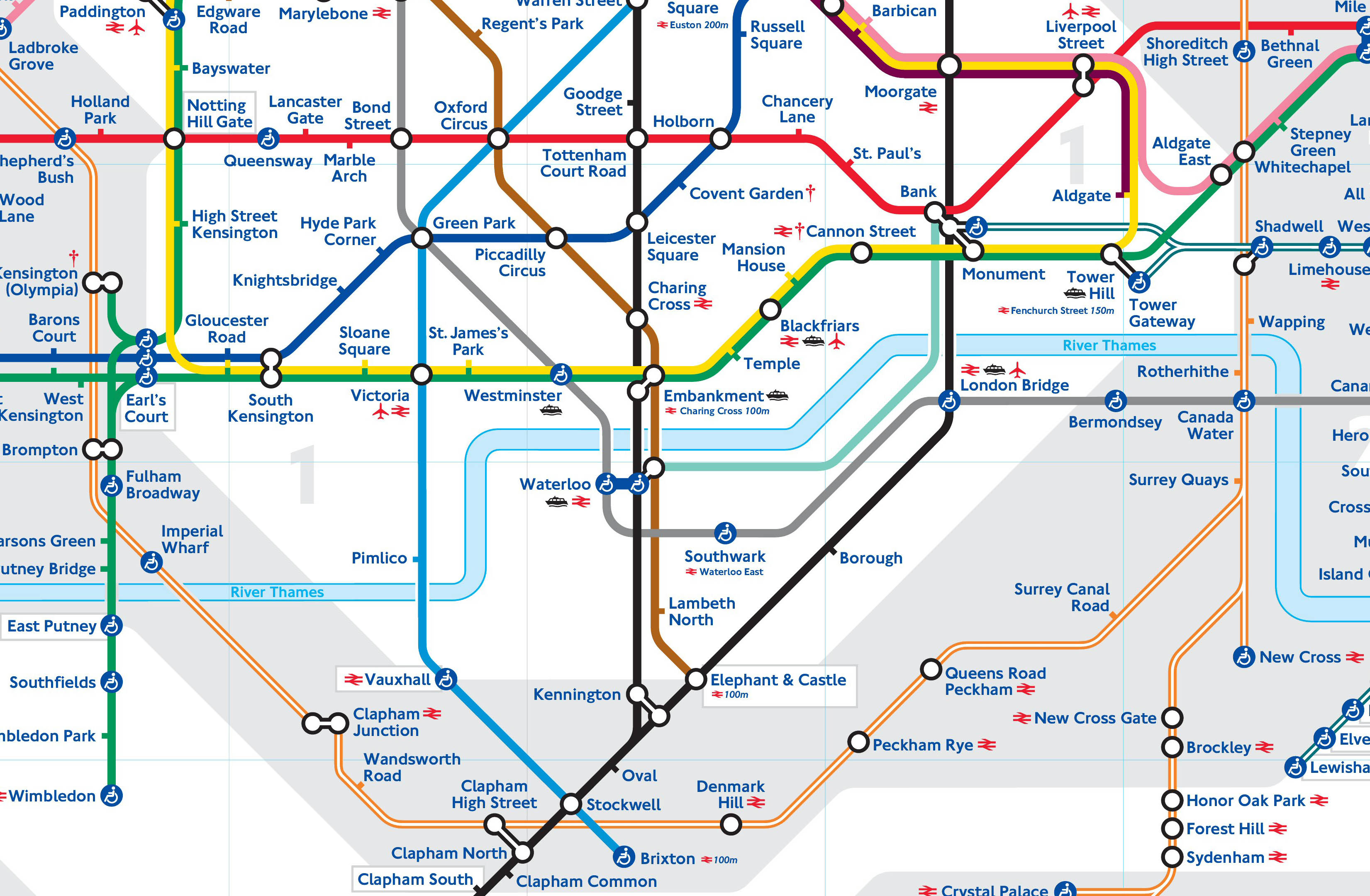
Our rail services to central London and to the Tube connections come from several different directions and run by different rail companies. The Tube map shows none of these connections as it shows just TfL services. London's Rail & Tube services map, shows Rail services and Tube lines, but is too detailed to get a clear picture about our Tube connections.
So Eileen and Corinne from Peckham Vision produced our own local map showing the rail services that connect us directly to the Tube, and to central London.
Here is the map showing the services from 9th December 2012, when the ELL (East London Line) comes into operation, and the SLL (South London Line) ceases operation after 145 years.

Download A5 size and send a link to this page to your visitors.
This SRUG map shows the many direct links there are in fact to the Tube in central London from SRUG stations. TfL's planned Tube map from December 2012 (see below), with the new ELL extension to Clapham Junction, shows Queens Road Peckham, Peckham Rye and Denmark Hill completely disconnected from central London. So our pocket size A5 map will be a useful addition to the Tube map for visitors to know how to navigate this part of the system as it is now.
TfL’s map
Tube map shows the way TfL sees our rail services - Queens Road, Peckham Rye and Denmark Hill disconnected from central London.
TfL run the Underground (Tube), the Docklands Light Railway (DLR) and the London Overground (Clapham Junction to Surrey Quays) formerly known as the East London Line (ELL). TfL’s Tube map shows only the connections between these three systems. The existing Tube map therefore does not show SRUG stations even though they are so close to central London and with good direct connections to the Tube system. This becomes even less helpful when the new tube map by 2013 will show Queen’s Rd Peckham, Peckham Rye, Denmark Hill on the Tube map for the first time see above, but show them as if totally cut off from central London.
Residents and visitors to our areas of Southwark are not served well by these official maps. This is why we are now developing our own from a local user perspective. Users, when travelling, are not interested in who runs the services but simply where we can get into the rail/tube system and the connections we can make.
The rail system is very complicated with numerous interacting routes and different train companies. We have decided to focus in our maps first on educating everyone how our SRUG stations are very well connected into the Tube system. The two obstacles in seeing this are that there is no handy diagram in our heads or our visitors' heads to remind us when we are out and about and planning our journeys. The other is that the rail services on our rail tracks are irregular and not frequent enough. To realise their potential as part of the integrated rail/tube systems we need regular and full services spanning the same hours as the Underground.
TfL are committed (page 35, 8.1.2) to achieving for all rail services in Greater London the same standards in coverage and regularity as the Underground including mimimum frequency of 4 trains an hour, but they are not responsible for all the relevant services. We need therefore to support their aims by drawing attention to the deficiencies at each stage when they might be remedied, eg when new rail service franchises are being drafted.
We also need to help the user to become much more familiar with seeing our rail services and stations as part of the integrated rail/tube interconnections. We hope our maps will contribute to this.
The impact of cutting the SLL, and the arrival of the ELL


Seeing the two maps side by side, it is easy to see how the ELL will replace the SLL. From Dec 2012 the ELL opens up new journeys east–west, but closes down some current ones going into central London. Some stations (Battersea Park, Wandsworth Rd, Clapham High St, Denmark Hill) will lose their links completely to London Bridge, others (Sth Bermondsey, Queens Rd Peckham) will lose the links to Victoria, and at Peckham Rye and Denmark Hill, the services to London Bridge and Victoria will be significantly reduced, and to & from Victoria, on current plans, will not run in the evenings or Sundays.
The maps also help to understand the complications in describing the effects of changes and cuts in the services into Victoria, London Bridge and Blackfriars/St Pancras, as they come from different directions. These services all come through and affect Peckham Rye, and they all go through some of the other SRUG stations. All services at the other SRUG stations come through Peckham Rye. This is why it makes it worthwhile to produce a map solely from the perspective of users of these 7 SRUG stations. In describing the effects of any changes in future we will be able to refer to the SRUG maps directly to make it easier to understand the complications.
Of course, the SRUG map then has to be read alongside all the other maps showing the other rail systems - Network Rail + Train Operating Companies, and TfL’s DLR (Docklands Light Railway) , London Overground, and Underground - that our local SRUG system connects to. We will continue to explore the development of our local maps for the benefit of local rail users.
These two maps below compare how TfL sees the services after the SLL has been stopped, and how local rail users had imagined and hoped the services would be with the ELL complementing the SLL. It will take 6 years until 2018 to rebuild London Bridge station which is the main reason for ending the South London Line (SLL) service. The SLL has served South London very well for nearly 150 years. It is still needed for uniquely South London journeys not least the need to link the Denmark Hill / Camberwell major hospitals to London Bridge and Victoria. The campaign to restore the SLL after London Bridge is rebuilt will continue. In the meantime the priority is to fill the gaps in our services to Victoria - bring back the trains in the evenings and on Sundays and restore the numbers of trains in crowded peak hours.
