Milestones in the South London Line Campaign 2009-2012
This first section of this page is a temporary collection of reports and information about the ending of the South London Line.
http://www.london-se1.co.uk/news/view/6480
BBC Radio London Mon 10th December 2012
_______________________________________________________________________
This is the archive for the milestones of the campaign to save the South London Line, that appeared on the SRUG Home page. The campaign was launched on 26 June 2009.
For more information on the campaign see here: www.bellenden.net/rail-cuts
and for the impact of the loss of the SLL see here: www.bellenden.net/SRUG-maps#impact
- The ELL begins on 9th December 2012.
- The SLL comes to an end on 8th December 2012.
- Battle to save SLL lost: The battle to save the SLL was lost as none of the rail bodies would create space at London Bridge for the SLL to terminate there while the station is being rebuilt during 2013-2019. In June 2010 TfL presented their report on how to ‘mitigate’ the loss of services to Victoria as a result of losing the SLL. See the report here. The focus now is to get the gaps in services to Victoria filled (see Victoria Services campaign) and to seek to have the SLL reinstated in 2019. For the archives of the campaign to Save the SLL see below and also here.
- “The South London Line: The Vital Link” : Campaign Group report published 1st Feb 2010
1 Feb 2010
The report shows how the key stations in south London will suffer, and how instead of cutting services in south London, TfL and the rail companies could be enhancing services, for just a moderate cost. Click here for a copy. - South London Line’s centenary - Tuesday 1st December 8am Denmark Hill
1 Dec 2009
We had a fun centenary celebration of the electrification of the South London Line. Some of us in Edwardian dress! see photos here here and here. Read Southwark News and South London Press and SLP here. The historic occasion deserved its ceremonial bottle of bubbly, and we toasted the future continued success of this service to Inner South London. Commemorative biscuits were enjoyed by all. read more about the SLL pioneering electrification - Mayor's Question time - Monday 9th November 7pm - 9pm
9 Nov 2009
At Brixton Academy (211 Stockwell Road, London SW9 9SL). Doors opened at 6pm. The "Save the South London Line" Campaign was there at 5.30pm displaying the new Save the South London Line Tshirts. The Academy was packed and a very lively evening on all topics. The SLL was mentioned several times in questions and comments and there was much loud support from the audience. The Mayor was left in no doubt of the importance of the SLL to south London. - Public Meeting Wednesday 30th September 2009 in Camberwell
30 Sep 2009
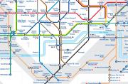
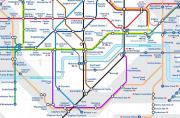
This campaign meeting was a historic event; see agenda here. Over 200 rail users turned up. First report on the meeting here. SRUG presented several maps showing why TfL needs to change the way it sees south London rail services; click on these maps to enlarge.TfL's Tube map 2012
TfL’s Tube map shows the way TfL sees our rail services - Queens Road, Peckham Rye and Denmark Hill disconnected from central London.
Tube map 2012 with ELLX & SLL
Our Tube map shows the South London Line on the map and as a key part of the integrated Zones 1 & 2 south London transport infrastructure.
See also the maps compared or the geographical maps showing the actual routes: close up, full map.
- Val Shawcross & Jenny Jones join campaigners at Denmark Hill on 22 September 2009 for pyama night time protest at loss of Victoria evening services
22 Sep 2009
On Tuesday 22 September 2009 Campaigners donned their bedclothes to highlight the loss of evening services to Victoria if the South London Line is scrapped. read more... - Tessa Jowell & Harriet Harman attend rally at Denmark Hill to fight rail cuts
26 June 2009
The official launch of the campaign against South London Trainline rail cuts was marked by a rally at Denmark Hill Friday 26th June 2009. Read more plus photos and video...
End of the South London Line: campaigners gather at London Bridge
Sunday 9 December 2012 London SE1 website team
Transport campaigners and local politicians gathered at London Bridge Station on Saturday morning to mark the final day of the inner South London Line service to Victoria via Peckham Rye.

