history
The Varied Transformations of a Christian Church
Sat, 24/04/2010 - 00:03 — Anonymous%2019Apr%2710St.MaryMagdaleneChurchPrepared4Demolition.jpg)
%2022Apr%2710St.Mary%20MagdaleneChurch%20Demolition.jpg)
.jpg)
.jpg)
%20Later%20in%20day%20only%20bell%20tower%20quadripod%20remains.jpg)
%2023rd%20April%202010%20St.%20Mary%20Magdalene%20Church%20is%20no%20more%20(for%20now).jpg)
%20Old%20St.%20Mary%20Magdalene%20Church%2c%20Nunhead.jpg)
%20St.%20Mary%20Magdalene%20Now%20Demolished.jpg)
Nunhead’s St. Mary Magdalene Church is demolished prior to a new rebuild. Photos show the flimsy constructed lead roofed modernist built church, replacing its predecessor destroyed by a WW2 air exploding bomb, is demolished in two days on the 22nd and 23rd of April 2010.
Peckham Rye Common boundary
Sun, 20/12/2009 - 01:02 — eileen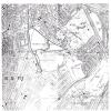
This is the authoritative map of the boundary of Peckham Rye Common, attached to the affidavit which transferred the Common to the London Borough of Southwark from the London County Council in the 1960s.
Peckham Rye Park, which is different from and distinct from the Common land of the Rye, is immediately adjacent to the south of the Common land and bounded by the roads Peckham Rye on east and west and by Colyton Road & Homestall Road to the south.
Old Picture Postcard View of Queen's Road
Mon, 09/11/2009 - 11:59 — admin
Trawling the web I came across this old postcard. I wonder if any of the houses still exist today.
Geo.G.Bussey & Co historic name
Wed, 05/08/2009 - 21:41 — eileen
This is a view of the Bussey building from the multi-storey car park. The original name of the company is still clearly visible along the side overlooking the railway tracks. This is the more decorative side of the building that is a good advertisement for the Bussey factory viewed by all rail passengers. Cleaned up it would still present a very impressive face of Peckham to all those who travel through on the trains. The current air of emptiness and dereliction is misleading as the building, and the site behind it, is full of small businesses, artists and other enterprises of various sorts. Further information on the Bussey building is on http://www.peckhamvision.org/wiki/Bussey_Building